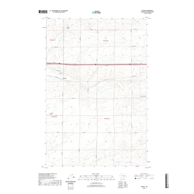
2020 Map of Schrag
USGS Topo · Published 2020About this map
The small settlement of Schrag sits at the center of this Adams County landscape, where the high desert plateau is carved by the distinct geological paths of Farrier Coulee and Bauer Coulee. This 2020 survey illustrates a region defined by large-scale agricultural holdings and a grid of rural section roads, many of which bear the names of local families who shaped the area's development. Features like Franz Rd and Leisle Rd lead to the Franz Ranch Airport, a private aviation strip that highlights the modern logistics of managing expansive ranch lands. The corridor of Interstate 90 bisects the northern half of the quadrangle, contrasting the fast-paced transit of the interstate with the quiet, winding routes of W Schrag Rd and Urquhart Rd that follow the natural contours of the coulees.
Find a feature on this map
25 named features on this map. Tap any name to fly to it.
Don’t see what you’re looking for? This feature index may not catch every label — zoom into the map to look around manually.
Map Details
Editions of this 2020 Schrag Map
This is the sole edition of this map. No revisions or reprints were ever made.
Other maps of this area

1916 · Connell
USGS Topo · 1:125,000

1918 · Connell
USGS Topo · 1:125,000

1925 · Schrag
USGS Topo · 1:62,500

1953 · Walla Walla
USGS Topo · 1:250,000

1953 · Ritzville
USGS Topo · 1:250,000

1958 · Walla Walla
USGS Topo · 1:250,000

1959 · Ritzville
USGS Topo · 1:250,000

1965 · Ritzville
USGS Topo · 1:250,000

1967 · Reiman SW
USGS Topo · 1:24,000
1967 · Ruff
USGS Topo · 1:24,000