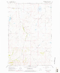
1961 Map of Schrammeck Lake
USGS Topo · Published 1980About this map
Schrammeck Lake and its surrounding high-plains landscape are documented in this mid-century topographic record of Cascade County. The geography is defined by a dendritic network of drainages, including Bird Creek, Willow Creek, and the Spanish Coulee, which cut through the terrain toward the Missouri River basin. Civil infrastructure is sparse, characterized by a few key thoroughfares like Adel Road and Millegan Road that link isolated ranchlands. Water management features prominently with the Gollaher Reservoir and its associated spillway, alongside numerous named springs and wells essential for livestock in this semi-arid environment. The area around Cameron demonstrates the typical Montana ranching pattern, where vast reaches of land are connected only by unimproved dirt tracks and a handful of primary county roads.
Find a feature on this map
16 named features on this map. Tap any name to fly to it.
Don’t see what you’re looking for? This feature index may not catch every label — zoom into the map to look around manually.
Map Details
Editions of this 1961 Schrammeck Lake Map
2 editions found
Other maps of this area

1886 · Great Falls
USGS Topo · 1:250,000

1949 · Cascade
USGS Topo · 1:62,500

1951 · Cascade
USGS Topo · 1:62,500

1954 · Great Falls
USGS Topo · 1:250,000

1955 · Gore Hill
USGS Topo · 1:62,500

1957 · Great Falls
USGS Topo · 1:250,000

1961 · Hound Creek Reservoir
USGS Topo · 1:24,000

1961 · Rocky Reef
USGS Topo · 1:24,000

1961 · Schrammeck Lake
USGS Topo · 1:24,000

1961 · Dana Ranch
USGS Topo · 1:24,000