
1955 Map of Schroeder
USGS Topo · Published 1978About this map
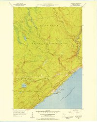
Lake Superior dominates the southeastern edge of this coastal survey, where the settlement of Schroeder and the industrial hub of Taconite Harbor overlook the water. The landscape is defined by the heavy presence of the timber and mining industries, evidenced by the Erie Mining Company Railroad cutting through the interior. These rails run south of a network of named waterways including Fredenberg Creek and the Two Island River, which navigate the dense woodlands of the Superior National Forest and Finland State Forest. To the north, the terrain becomes increasingly complex with features like Stumble Creek and Heartbreak Creek feeding into the larger Cross River. Small inland bodies of water such as Dyers Lake and Dogwood Lake are noted among the elevations, while offshore landmarks like Gull Island and Bear Island mark the transition into the open lake.
Find a feature on this map
25 named features on this map. Tap any name to fly to it.
Don’t see what you’re looking for? This feature index may not catch every label — zoom into the map to look around manually.
Map Details
Editions of this 1955 Schroeder Map
2 editions found
Historical Maps of Schroeder Through Time
278 maps found

1919 Brule Lake
Cook County, MN
1955 Schroeder
Cook County, MN

1955 Tofte
Cook County, MN

1955 Tofte
Cook County, MN

1957 Quetico
Cook County, MN

1958 Deer Yard Lake
Cook County, MN

1958 Good Harbor Bay
Cook County, MN

1959 Conners Island
Cook County, MN

1959 Crocodile Lake
Cook County, MN

1959 Gillis Lake
Cook County, MN

1959 Grand Portage
Cook County, MN

1959 Hungry Jack Lake
Cook County, MN

1959 Lima Mountain
Cook County, MN

1959 Mineral Center
Cook County, MN

1959 Munker Island
Cook County, MN

1959 Northern Light Lake
Cook County, MN

1959 Pigeon Point
Cook County, MN

1959 Pine Lake East
Cook County, MN

1959 Pine Lake West
Cook County, MN

1959 Pine Mountain
Cook County, MN

1959 Tom Lake
Cook County, MN

1960 Beth Lake
Cook County, MN

1960 Brule Lake
Cook County, MN

1960 Cherokee Lake
Cook County, MN

1960 Devil Track Lake
Cook County, MN

1960 Eagle Mountain
Cook County, MN

1960 Farquhar Peak
Cook County, MN

1960 Gunflint Lake
Cook County, MN

1960 Hovland
Cook County, MN

1960 Kadunce River
Cook County, MN

1960 Kelso Mountain
Cook County, MN

1960 Long Island Lake
Cook County, MN

1960 Mark Lake
Cook County, MN

1960 Marr Island
Cook County, MN

1960 Sawbill Camp
Cook County, MN

1960 South Fowl Lake
Cook County, MN

1960 South Lake
Cook County, MN

1960 Tait Lake
Cook County, MN

1960 The Cascades
Cook County, MN

1968 Quetico
Cook County, MN

1976 Saganaga Lake
Cook County, MN

1981 Honeymoon Mountain
Cook County, MN

1981 Toohey Lake
Cook County, MN

1985 Grand Portage
Cook County, MN

1985 Pigeon Point
Cook County, MN

1999 Grand Portage
Cook County, MN

1999 Mineral Center
Cook County, MN

1999 Pigeon Point
Cook County, MN

1999 The Cascades
Cook County, MN

2011 Beth Lake
Cook County, MN

2011 Brule Lake
Cook County, MN

2011 Cherokee Lake
Cook County, MN

2011 Conners Island
Cook County, MN

2011 Crocodile Lake
Cook County, MN

2011 Deer Yard Lake
Cook County, MN

2011 Devil Track Lake
Cook County, MN

2011 Eagle Mountain
Cook County, MN

2011 Farquhar Peak
Cook County, MN

2011 Gillis Lake
Cook County, MN

2011 Good Harbor Bay
Cook County, MN

2011 Good Harbor Bay OE E
Cook County, MN

2011 Grand Portage
Cook County, MN

2011 Grand Portage OE N
Cook County, MN

2011 Gunflint Lake
Cook County, MN

2011 Honeymoon Mountain
Cook County, MN

2011 Hovland
Cook County, MN

2011 Hungry Jack Lake
Cook County, MN

2011 Kadunce River
Cook County, MN

2011 Kelso Mountain
Cook County, MN

2011 Lima Mountain
Cook County, MN

2011 Little Marais OE E
Cook County, MN

2011 Long Island Lake
Cook County, MN

2011 Lutsen OE S
Cook County, MN

2011 Mark Lake
Cook County, MN

2011 Marr Island
Cook County, MN

2011 Mineral Center
Cook County, MN

2011 Mineral Center OE S
Cook County, MN

2011 Munker Island
Cook County, MN

2011 Northern Light Lake
Cook County, MN

2011 Pigeon Point
Cook County, MN

2011 Pigeon Point OE N
Cook County, MN

2011 Pigeon Point OE NE
Cook County, MN

2011 Pine Lake East
Cook County, MN

2011 Pine Lake West
Cook County, MN

2011 Pine Mountain
Cook County, MN

2011 Sawbill Camp
Cook County, MN

2011 Schroeder
Cook County, MN

2011 South Lake
Cook County, MN

2011 Tait Lake
Cook County, MN

2011 The Cascades
Cook County, MN

2011 Tofte
Cook County, MN

2011 Tom Lake
Cook County, MN

2011 Toohey Lake
Cook County, MN

2012 South Fowl Lake
Cook County, MN

2013 Beth Lake
Cook County, MN

2013 Brule Lake
Cook County, MN

2013 Cherokee Lake
Cook County, MN

2013 Conners Island
Cook County, MN

2013 Crocodile Lake
Cook County, MN

2013 Deer Yard Lake
Cook County, MN

2013 Devil Track Lake
Cook County, MN

2013 Eagle Mountain
Cook County, MN

2013 Farquhar Peak
Cook County, MN

2013 Gillis Lake
Cook County, MN

2013 Good Harbor Bay
Cook County, MN

2013 Good Harbor Bay OE E
Cook County, MN

2013 Grand Portage
Cook County, MN

2013 Grand Portage OE N
Cook County, MN

2013 Gunflint Lake
Cook County, MN

2013 Honeymoon Mountain
Cook County, MN

2013 Hovland
Cook County, MN

2013 Hungry Jack Lake
Cook County, MN

2013 Kadunce River
Cook County, MN

2013 Kelso Mountain
Cook County, MN

2013 Lima Mountain
Cook County, MN

2013 Little Marais OE E
Cook County, MN

2013 Long Island Lake
Cook County, MN

2013 Lutsen OE S
Cook County, MN

2013 Mark Lake
Cook County, MN

2013 Marr Island
Cook County, MN

2013 Mineral Center
Cook County, MN

2013 Mineral Center OE S
Cook County, MN

2013 Munker Island
Cook County, MN

2013 Northern Light Lake
Cook County, MN

2013 Pigeon Point
Cook County, MN

2013 Pigeon Point OE E
Cook County, MN

2013 Pigeon Point OE N
Cook County, MN

2013 Pigeon Point OE NE
Cook County, MN

2013 Pine Lake East
Cook County, MN

2013 Pine Lake West
Cook County, MN

2013 Pine Mountain
Cook County, MN

2013 Sawbill Camp
Cook County, MN

2013 Schroeder
Cook County, MN

2013 South Fowl Lake
Cook County, MN

2013 South Lake
Cook County, MN

2013 Tait Lake
Cook County, MN

2013 The Cascades
Cook County, MN

2013 Tofte
Cook County, MN

2013 Tom Lake
Cook County, MN

2013 Toohey Lake
Cook County, MN

2016 Beth Lake
Cook County, MN

2016 Brule Lake
Cook County, MN

2016 Cherokee Lake
Cook County, MN

2016 Conners Island
Cook County, MN

2016 Crocodile Lake
Cook County, MN

2016 Deer Yard Lake
Cook County, MN

2016 Devil Track Lake
Cook County, MN

2016 Eagle Mountain
Cook County, MN

2016 Farquhar Peak
Cook County, MN

2016 Gillis Lake
Cook County, MN

2016 Good Harbor Bay
Cook County, MN

2016 Good Harbor Bay OE E
Cook County, MN

2016 Grand Portage
Cook County, MN

2016 Grand Portage OE N
Cook County, MN

2016 Gunflint Lake
Cook County, MN

2016 Honeymoon Mountain
Cook County, MN

2016 Hovland
Cook County, MN

2016 Hungry Jack Lake
Cook County, MN

2016 Kadunce River
Cook County, MN

2016 Kelso Mountain
Cook County, MN

2016 Lima Mountain
Cook County, MN

2016 Little Marais OE E
Cook County, MN

2016 Long Island Lake
Cook County, MN

2016 Lutsen OE S
Cook County, MN

2016 Mark Lake
Cook County, MN

2016 Marr Island
Cook County, MN

2016 Mineral Center
Cook County, MN

2016 Mineral Center OE S
Cook County, MN

2016 Munker Island
Cook County, MN

2016 Northern Light Lake
Cook County, MN

2016 Pigeon Point
Cook County, MN

2016 Pigeon Point OE E
Cook County, MN

2016 Pigeon Point OE N
Cook County, MN

2016 Pigeon Point OE NE
Cook County, MN

2016 Pine Lake East
Cook County, MN

2016 Pine Lake West
Cook County, MN

2016 Pine Mountain
Cook County, MN

2016 Sawbill Camp
Cook County, MN

2016 Schroeder
Cook County, MN

2016 South Fowl Lake
Cook County, MN

2016 South Lake
Cook County, MN

2016 Tait Lake
Cook County, MN

2016 The Cascades
Cook County, MN

2016 Tofte
Cook County, MN

2016 Tom Lake
Cook County, MN

2016 Toohey Lake
Cook County, MN

2019 Beth Lake
Cook County, MN

2019 Brule Lake
Cook County, MN

2019 Cherokee Lake
Cook County, MN

2019 Conners Island
Cook County, MN

2019 Crocodile Lake
Cook County, MN

2019 Deer Yard Lake
Cook County, MN

2019 Devil Track Lake
Cook County, MN

2019 Eagle Mountain
Cook County, MN

2019 Farquhar Peak
Cook County, MN

2019 Gillis Lake
Cook County, MN

2019 Good Harbor Bay
Cook County, MN

2019 Good Harbor Bay OE E
Cook County, MN

2019 Grand Portage
Cook County, MN

2019 Grand Portage OE N
Cook County, MN

2019 Gunflint Lake
Cook County, MN

2019 Honeymoon Mountain
Cook County, MN

2019 Hovland
Cook County, MN

2019 Hungry Jack Lake
Cook County, MN

2019 Kadunce River
Cook County, MN

2019 Kelso Mountain
Cook County, MN

2019 Lima Mountain
Cook County, MN

2019 Little Marais OE E
Cook County, MN

2019 Long Island Lake
Cook County, MN

2019 Lutsen OE S
Cook County, MN

2019 Mark Lake
Cook County, MN

2019 Marr Island
Cook County, MN

2019 Mineral Center
Cook County, MN

2019 Mineral Center OE S
Cook County, MN

2019 Munker Island
Cook County, MN

2019 Northern Light Lake
Cook County, MN

2019 Pigeon Point
Cook County, MN

2019 Pigeon Point OE E
Cook County, MN

2019 Pigeon Point OE N
Cook County, MN

2019 Pigeon Point OE NE
Cook County, MN

2019 Pine Lake East
Cook County, MN

2019 Pine Lake West
Cook County, MN

2019 Pine Mountain
Cook County, MN

2019 Sawbill Camp
Cook County, MN

2019 Schroeder
Cook County, MN

2019 South Fowl Lake
Cook County, MN

2019 South Lake
Cook County, MN

2019 Tait Lake
Cook County, MN

2019 The Cascades
Cook County, MN

2019 Tofte
Cook County, MN

2019 Tom Lake
Cook County, MN

2019 Toohey Lake
Cook County, MN

2022 Beth Lake
Cook County, MN

2022 Brule Lake
Cook County, MN

2022 Cherokee Lake
Cook County, MN

2022 Conners Island
Cook County, MN

2022 Crocodile Lake
Cook County, MN

2022 Deer Yard Lake
Cook County, MN

2022 Devil Track Lake
Cook County, MN

2022 Eagle Mountain
Cook County, MN

2022 Farquhar Peak
Cook County, MN

2022 Gillis Lake
Cook County, MN

2022 Good Harbor Bay
Cook County, MN

2022 Good Harbor Bay OE E
Cook County, MN

2022 Grand Portage
Cook County, MN

2022 Grand Portage OE N
Cook County, MN

2022 Gunflint Lake
Cook County, MN

2022 Honeymoon Mountain
Cook County, MN

2022 Hovland
Cook County, MN

2022 Hungry Jack Lake
Cook County, MN

2022 Kadunce River
Cook County, MN

2022 Kelso Mountain
Cook County, MN

2022 Lima Mountain
Cook County, MN

2022 Little Marais OE E
Cook County, MN

2022 Long Island Lake
Cook County, MN

2022 Lutsen OE S
Cook County, MN

2022 Mark Lake
Cook County, MN

2022 Marr Island
Cook County, MN

2022 Mineral Center
Cook County, MN

2022 Mineral Center OE S
Cook County, MN

2022 Munker Island
Cook County, MN

2022 Northern Light Lake
Cook County, MN

2022 Pigeon Point
Cook County, MN

2022 Pigeon Point OE E
Cook County, MN

2022 Pigeon Point OE N
Cook County, MN

2022 Pigeon Point OE NE
Cook County, MN

2022 Pine Lake East
Cook County, MN

2022 Pine Lake West
Cook County, MN

2022 Pine Mountain
Cook County, MN

2022 Sawbill Camp
Cook County, MN

2022 Schroeder
Cook County, MN

2022 South Fowl Lake
Cook County, MN

2022 South Lake
Cook County, MN

2022 Tait Lake
Cook County, MN

2022 The Cascades
Cook County, MN

2022 Tofte
Cook County, MN

2022 Tom Lake
Cook County, MN

2022 Toohey Lake
Cook County, MN
Featured Locations
- Cook County, MN
- Schroeder Township, MN
- Tofte Township, MN
- Schroeder, Schroeder Township
- Taconite Harbor, Schroeder Township