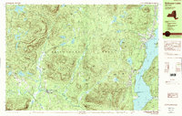
1989 Map of Schroon Lake
USGS Topo · Published 1989About this map
Adirondack Park dominates the landscape of this 1989 survey, where the interconnected waterways of the high peaks define the regional layout. The prominent expanse of Schroon Lake serves as the primary focal point, anchored by the village of Schroon Lake at its northern reach and South Schroon near The Narrows. To the west, the landscape transitions into a dense network of smaller basins and peaks, including Minerva Lake and Moxham Mtn. Settlement patterns follow the valley floors and stream beds, with established communities like Minerva, Olmstedville, and Irishtown clustered along the southern and western corridors. The map captures a moment when these traditional Adirondack hamlets maintained their distinct footprints amidst a terrain of significant elevation changes, from the heights of Hayes Mtn to the winding course of the Schroon River.
Find a feature on this map
65 named features on this map. Tap any name to fly to it.
Don’t see what you’re looking for? This feature index may not catch every label — zoom into the map to look around manually.
Map Details
Editions of this 1989 Schroon Lake Map
2 editions found
Other maps of this area

1895 · North Creek
USGS Topo · 1:62,500

1895 · Paradox Lake
USGS Topo · 1:62,500

1897 · Bolton
USGS Topo · 1:62,500

1897 · Paradox Lake
USGS Topo · 1:62,500

1897 · North Creek
USGS Topo · 1:62,500

1897 · Schroon Lake
USGS Topo · 1:62,500

1898 · Newcomb
USGS Topo · 1:62,500

1898 · Thirteenth Lake
USGS Topo · 1:62,500

1900 · Bolton
USGS Topo · 1:62,500

1901 · Newcomb
USGS Topo · 1:62,500