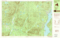
1989 Map of Schroon Lake
USGS Topo · Published 1989About this map
Olmstedville and Schroon Lake anchor this late-1980s landscape within the Adirondack Park, where the transition from lakefront tourism to deep mountain interior is clearly defined. The eastern edge is dominated by the long reach of Schroon Lake, featuring a Boat Ramp, a Golf Course, and clusters of development at South Schroon. Moving west, the terrain rises toward the interior peaks of Minerva, where small settlements like Irishtown and Loch-Muller sit along winding valley roads. A prominent Snowmobile Trail cuts through the timbered heights between Muller Pond and Bailey Pond, illustrating the region's recreation-based economy. The map preserves the locations of local landmarks such as the Cem in Olmstedville and a Gravel Pit near Trout Brook, providing essential data for those tracing the industrial and genealogical history of these mountain hamlets.
Find a feature on this map
67 named features on this map. Tap any name to fly to it.
Don’t see what you’re looking for? This feature index may not catch every label — zoom into the map to look around manually.
Map Details
Editions of this 1989 Schroon Lake Map
2 editions found
Other maps of this area

1895 · North Creek
USGS Topo · 1:62,500

1895 · Paradox Lake
USGS Topo · 1:62,500

1897 · Bolton
USGS Topo · 1:62,500

1897 · Paradox Lake
USGS Topo · 1:62,500

1897 · North Creek
USGS Topo · 1:62,500

1897 · Schroon Lake
USGS Topo · 1:62,500

1898 · Newcomb
USGS Topo · 1:62,500

1898 · Thirteenth Lake
USGS Topo · 1:62,500

1900 · Bolton
USGS Topo · 1:62,500

1901 · Newcomb
USGS Topo · 1:62,500