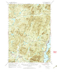
1953 Map of Schroon Lake
USGS Topo · Published 1967About this map
Schroon Lake serves as the central anchor for this mid-century survey of the southeastern Adirondack Mountains, where the village of Schroon Lake and neighboring South Schroon line the western shore. The map documents a transition from established valley settlements to the wilderness of the Blue Ridge Range. In the western portion, the small hamlets of Minerva, Irishtown, and Olmstedville are connected by local roads, with community landmarks like St Marys Church and St Marys Cemetery providing valuable reference points for family historians.
Find a feature on this map
116 named features on this map. Tap any name to fly to it.
Don’t see what you’re looking for? This feature index may not catch every label — zoom into the map to look around manually.
Map Details
Editions of this 1953 Schroon Lake Map
4 editions found

Other maps of this area

1894 · Elizabethtown
USGS Topo · 1:62,500

1895 · Elizabethtown
USGS Topo · 1:62,500

1895 · North Creek
USGS Topo · 1:62,500

1895 · Mt. Marcy
USGS Topo · 1:62,500

1895 · Paradox Lake
USGS Topo · 1:62,500

1897 · Bolton
USGS Topo · 1:62,500

1897 · Paradox Lake
USGS Topo · 1:62,500

1897 · North Creek
USGS Topo · 1:62,500

1897 · Schroon Lake
USGS Topo · 1:62,500

1898 · Newcomb
USGS Topo · 1:62,500