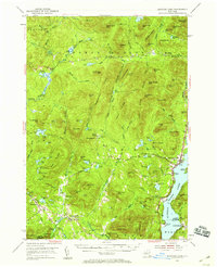
1953 Map of Schroon Lake
USGS Topo · Published 1959About this map
Schroon Lake dominates the eastern edge of this mid-century survey, serving as a recreational and civic anchor for the surrounding forest lands. To the west, the settlements of Olmstedville, Minerva, and the neighborhood of Irishtown represent the localized human geography of the southern Adirondacks, complete with St Marys Ch and its adjacent Cem. The landscape is a complex system of named peaks and water bodies, where Hoffman Mtn and the Blue Ridge Range define the high ground, while the Boreas River and Trout Brook drain the interior valleys.
Find a feature on this map
113 named features on this map. Tap any name to fly to it.
Don’t see what you’re looking for? This feature index may not catch every label — zoom into the map to look around manually.
Map Details
Editions of this 1953 Schroon Lake Map
4 editions found

Other maps of this area

1894 · Elizabethtown
USGS Topo · 1:62,500

1895 · Elizabethtown
USGS Topo · 1:62,500

1895 · North Creek
USGS Topo · 1:62,500

1895 · Mt. Marcy
USGS Topo · 1:62,500

1895 · Paradox Lake
USGS Topo · 1:62,500

1897 · Bolton
USGS Topo · 1:62,500

1897 · Paradox Lake
USGS Topo · 1:62,500

1897 · North Creek
USGS Topo · 1:62,500

1897 · Schroon Lake
USGS Topo · 1:62,500

1898 · Newcomb
USGS Topo · 1:62,500