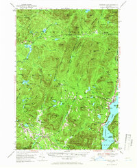
1953 Map of Schroon Lake
USGS Topo · Published 1965About this map
Schroon Lake serves as the focal point for this mid-century survey, with the lakeside resort community of the same name showing its street layout and recreational development, including a Golf Course and Grove Point. The map illustrates the contrasting landscapes of eastern Adirondack life, from the established village of Minerva to the high-elevation notches and ridges. Settlement patterns follow the water and valleys, with clusters of activity at Olmstedville, South Schroon, and the small community of Irishtown.
Find a feature on this map
129 named features on this map. Tap any name to fly to it.
Don’t see what you’re looking for? This feature index may not catch every label — zoom into the map to look around manually.
Map Details
Editions of this 1953 Schroon Lake Map
4 editions found

Other maps of this area

1894 · Elizabethtown
USGS Topo · 1:62,500

1895 · Elizabethtown
USGS Topo · 1:62,500

1895 · North Creek
USGS Topo · 1:62,500

1895 · Mt. Marcy
USGS Topo · 1:62,500

1895 · Paradox Lake
USGS Topo · 1:62,500

1897 · Bolton
USGS Topo · 1:62,500

1897 · Paradox Lake
USGS Topo · 1:62,500

1897 · North Creek
USGS Topo · 1:62,500

1897 · Schroon Lake
USGS Topo · 1:62,500

1898 · Newcomb
USGS Topo · 1:62,500