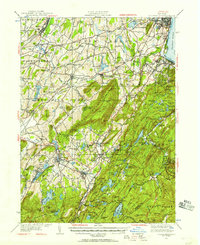
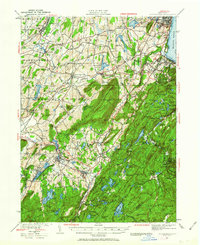
1930 Map of Schunemunk
USGS Topo · Published 1957About this map
Schunemunk Mountain dominates the center of this 1930s landscape, serving as a divider between the industrial river towns of the Hudson River and the agricultural settlements to the west. The area's complex transportation network is clearly defined by the Erie RR and New York Ontario and Western RR, which supported local economies in places like Salisbury Mills and Harriman. Further east, the rugged terrain of the West Point Military Reservation is dotted with high peaks like Bear Mtn and Mt Misery.
Find a feature on this map
138 named features on this map. Tap any name to fly to it.
Don’t see what you’re looking for? This feature index may not catch every label — zoom into the map to look around manually.
Map Details
Editions of this 1930 Schunemunk Map
3 editions found

Other maps of this area

1891 · Greenwood Lake
USGS Topo · 1:62,500

1891 · Ramapo
USGS Topo · 1:62,500

1892 · West Point
USGS Topo · 1:62,500

1892 · Tarrytown
USGS Topo · 1:62,500

1893 · Greenwood Lake
USGS Topo · 1:62,500

1893 · Tarrytown
USGS Topo · 1:62,500

1893 · Ramapo
USGS Topo · 1:62,500

1893 · Poughkeepsie
USGS Topo · 1:62,500

1894 · West Point
USGS Topo · 1:62,500

1894 · Poughkeepsie
USGS Topo · 1:62,500