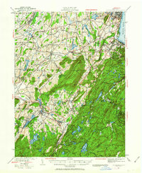
1930 Map of Schunemunk
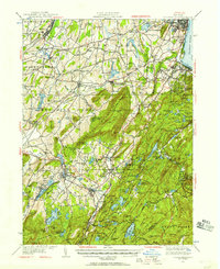
USGS Topo · Published 1963About this map
Schunemunk Mountain dominates the center of this landscape, a massive ridge flanked by the evolving industrial and agricultural communities of Orange County. To the east, the Hudson River serves as a vital artery, supporting the riverside economies of Cornwall on the Hudson and Firthcliffe. The transport network is particularly dense, showing the convergence of the Erie RR, West Shore RR, and the New York Ontario and Western Ry, which facilitated movement between hubs like Washingtonville and Maybrook.
Find a feature on this map
163 named features on this map. Tap any name to fly to it.
Don’t see what you’re looking for? This feature index may not catch every label — zoom into the map to look around manually.
Map Details
Editions of this 1930 Schunemunk Map
3 editions found

Other maps of this area

1891 · Greenwood Lake
USGS Topo · 1:62,500

1891 · Ramapo
USGS Topo · 1:62,500

1892 · West Point
USGS Topo · 1:62,500

1892 · Tarrytown
USGS Topo · 1:62,500

1893 · Greenwood Lake
USGS Topo · 1:62,500

1893 · Tarrytown
USGS Topo · 1:62,500

1893 · Ramapo
USGS Topo · 1:62,500

1893 · Poughkeepsie
USGS Topo · 1:62,500

1894 · West Point
USGS Topo · 1:62,500

1894 · Poughkeepsie
USGS Topo · 1:62,500