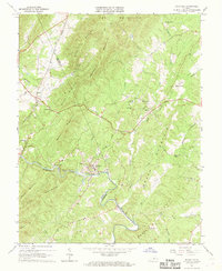
1967 Map of Schuyler
USGS Topo · Published 1968About this map
The Rockfish River winds through the heart of the Blue Ridge foothills on the border of AlbEMARLE and Nelson Counties, anchoring the industrial and social life of the region in the late 1960s. The settlement of Schuyler is a focal point of activity, featuring a Quarry, Powerplant, and several community landmarks like Bethel Ch. This industrial footprint contrasts with the surrounding ridge-and-valley landscape, where high points such as Appleberry Mountain and Shiloh Mountain dictate the path of local roads.
Find a feature on this map
54 named features on this map. Tap any name to fly to it.
Don’t see what you’re looking for? This feature index may not catch every label — zoom into the map to look around manually.
Map Details
Editions of this 1967 Schuyler Map
Other maps of this area

1892 · Buckingham
USGS Topo · 1:125,000

1929 · Covesville
USGS Topo · 1:62,500

1935 · Covesville
USGS Topo · 1:62,500

1943 · Lovingston
USGS Topo · 1:62,500

1945 · Covesville
USGS Topo · 1:62,500

1946 · Lovingston
USGS Topo · 1:62,500

1947 · Roanoke
USGS Topo · 1:250,000

1959 · Roanoke
USGS Topo · 1:250,000

1961 · Shipman
USGS Topo · 1:62,500

1961 · Buckingham
USGS Topo · 1:62,500