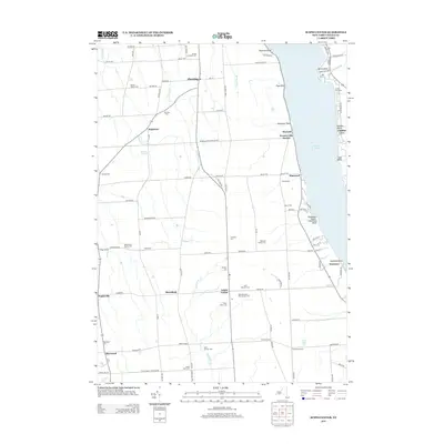
2013 Map of Scipio Center
USGS Topo · Published 2013About this map
Owasco Lake dominates the eastern boundary of this landscape, its western shoreline marked by a dense string of seasonal and permanent settlements including Glenwood Beach, Elmwood, and Wyckoff. The interior of Cayuga County is defined by agricultural lands and small crossroads communities like Scipio Center and Merrifield. Numerous family and community burial grounds, such as the Arnold Comstock Cem and Saint Bernard's Old Catholic Cem, are scattered across the terrain, reflecting generations of local lineage. The drainage of Yawger Cr and Crane Brook cuts through the fields, illustrating the local hydrology that shaped early settlement patterns. Between the lakefront at Ensenore and the rural stretches of Sherwood, this map documents the persistent layout of town lines and rural routes like the Fleming Scipio Town Line Rd in the early 21st century.
Find a feature on this map
104 named features on this map. Tap any name to fly to it.
Don’t see what you’re looking for? This feature index may not catch every label — zoom into the map to look around manually.
Map Details
Editions of this 2013 Scipio Center Map
This is the sole edition of this map. No revisions or reprints were ever made.
Other maps of this area

1898 · Moravia
USGS Topo · 1:62,500

1899 · Auburn
USGS Topo · 1:62,500

1899 · Skaneateles
USGS Topo · 1:62,500

1902 · Skaneateles
USGS Topo · 1:62,500

1902 · Moravia
USGS Topo · 1:62,500

1902 · Genoa
USGS Topo · 1:62,500

1902 · Auburn
USGS Topo · 1:62,500

1942 · Sheldrake
USGS Topo · 1:24,000

1942 · Genoa
USGS Topo · 1:24,000

1943 · Moravia
USGS Topo · 1:31,680