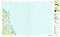
1984 Map of Scituate
USGS Topo · Published 1984About this map
The dramatic glacial shoreline of Massachusetts Bay defines this mid-1980s look at Plymouth County. The coastal landscape is marked by a sequence of prominent headlands, from First Cliff down to Fourth Cliff, protecting smaller coves and the vital Scituate Harbor. Inland, the tidal complex of the North River and South River creates a labyrinth of marshes and islands, including Trouant Island and Bear Island. This period shows the established residential character of seaside communities like Egypt Beach, Sand Hills, and Humarock. Cultural anchors are well-documented, including several schools like Jenkins Sch and local landmarks such as the Lighthouse at Cedar Point. For genealogists, the map identifies specific burial grounds like Union Cem and Meeting House Lane Cem, alongside institutional sites like the US Coast Guard Station.
Find a feature on this map
66 named features on this map. Tap any name to fly to it.
Don’t see what you’re looking for? This feature index may not catch every label — zoom into the map to look around manually.
Map Details
Editions of this 1984 Scituate Map
2 editions found
Other maps of this area

1885 · Abington
USGS Topo · 1:62,500

1885 · Duxbury
USGS Topo · 1:62,500

1888 · Duxbury
USGS Topo · 1:62,500

1888 · Abington
USGS Topo · 1:62,500

1892 · Boston Bay
USGS Topo · 1:62,500

1893 · Abington
USGS Topo · 1:62,500

1893 · Duxbury
USGS Topo · 1:62,500

1903 · Boston Bay
USGS Topo · 1:62,500

1918 · Duxbury
USGS Topo · 1:62,500

1920 · Abington
USGS Topo · 1:62,500