
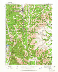
1923 Map of Scofield
USGS Topo · Published 1957About this map
Coal extraction and railway infrastructure define this high-country landscape during the early 1920s. The town of Scofield serves as a primary hub, connected to the industrial operations at Clear Creek via the Denver & Rio Grande Western RR. This Pleasant Valley Branch of the railroad provides a vital link for the numerous mining operations scattered throughout the deep canyons, including the Utah Mine, Gibson Mine, and the extensive Clear Creek Mines No 4 No 3.
Find a feature on this map
78 named features on this map. Tap any name to fly to it.
Don’t see what you’re looking for? This feature index may not catch every label — zoom into the map to look around manually.
Map Details
Editions of this 1923 Scofield Map
2 editions found
Other maps of this area

1885 · Manti
USGS Topo · 1:250,000

1886 · Price River
USGS Topo · 1:250,000

1895 · Manti
USGS Topo · 1:250,000

1896 · Price River
USGS Topo · 1:250,000

1914 · Castle Gate
USGS Topo · 1:62,500

1916 · Castle Gate
USGS Topo · 1:62,500

1923 · Hiawatha
USGS Topo · 1:62,500

1925 · Scofield
USGS Topo · 1:62,500

1925 · Hiawatha
USGS Topo · 1:62,500

1939 · Soldier Summit
USGS Topo · 1:62,500