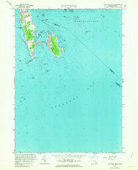
1962 Map of Sconticut Neck
USGS Topo · Published 1963About this map
Sconticut Neck and West Island dominate this coastal survey, linked by a thin Causeway that bridges the waters of Nasketucket Bay. The map captures a maritime landscape defined by shifting shoals and rocky hazards, including Angelica Rock, Whale Rock, and the Cormorant Rock Beacon. Inland, a dense grid of residential streets appears on the western shore of West Island, while the mainland portion of the neck remains more sparsely developed, centered along a primary north-south Road. To the east, the waters of Mattapoisett reveal numerous maritime landmarks like Brant Island and Mattapoisett Ledge. This 1962 revision provides a detailed view of the coastal interface before modern development expanded, showing the original footprints of local landmarks like Silver Shell Beach and the various islands and ledges that defined the hazardous approach to this portion of Buzzards Bay.
Find a feature on this map
41 named features on this map. Tap any name to fly to it.
Don’t see what you’re looking for? This feature index may not catch every label — zoom into the map to look around manually.
Map Details
Editions of this 1962 Sconticut Neck Map
2 editions found
Other maps of this area

1885 · New Bedford
USGS Topo · 1:62,500

1886 · Falmouth
USGS Topo · 1:62,500

1887 · Gay Head
USGS Topo · 1:62,500

1888 · New Bedford
USGS Topo · 1:62,500

1888 · Falmouth
USGS Topo · 1:62,500

1889 · Gay Head
USGS Topo · 1:62,500

1893 · Gay Head
USGS Topo · 1:62,500

1893 · Falmouth
USGS Topo · 1:62,500

1893 · New Bedford
USGS Topo · 1:62,500

1915 · Falmouth
USGS Topo · 1:62,500