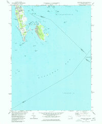
1975 Map of Sconticut Neck
USGS Topo · Published 1977About this map
Sconticut Neck extends into the coastal waters of Buzzards Bay, serving as a narrow finger of land that separates Nasketucket Bay from the open sea. This mid-1970s survey captures the residential and recreational layout of the Fairhaven coast, where Sconticut Neck Road provides the primary spine for local access. The landscape is defined by its relationship with the water, featuring a slender Causeway that links the mainland to West Island, a community crisscrossed by West Island Street and dotted with small ponds like Long Pond. The map reveals an intricate marine environment, marked by numerous hazards and landmarks such as Cormorant Rock Beacon and Black Rock Beacon. These features, along with named outcrops like Old Kelick Rock and Puppy Rocks, highlight the navigational complexity of the Massachusetts shoreline during this period of coastal development.
Find a feature on this map
45 named features on this map. Tap any name to fly to it.
Don’t see what you’re looking for? This feature index may not catch every label — zoom into the map to look around manually.
Map Details
Editions of this 1975 Sconticut Neck Map
2 editions found
Other maps of this area

1885 · New Bedford
USGS Topo · 1:62,500

1886 · Falmouth
USGS Topo · 1:62,500

1887 · Gay Head
USGS Topo · 1:62,500

1888 · New Bedford
USGS Topo · 1:62,500

1888 · Falmouth
USGS Topo · 1:62,500

1889 · Gay Head
USGS Topo · 1:62,500

1893 · Gay Head
USGS Topo · 1:62,500

1893 · Falmouth
USGS Topo · 1:62,500

1893 · New Bedford
USGS Topo · 1:62,500

1915 · Falmouth
USGS Topo · 1:62,500