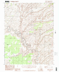
1987 Map of Scorpion Gulch
USGS Topo · Published 1995About this map
The Escalante River carves a deep, winding path through the center of this landscape, its tight meanders defining the drainage patterns of the high desert plateau. Within the Glen Canyon National Recreation Area, the terrain is dominated by high mesas and deep incisions, such as Middle Moody Canyon and East Moody Canyon, which feed into the main river system from the north. The southern portion of the sheet is marked by the eponymous Scorpion Gulch, crossing the boundary between Garfield and Kane Counties. On the western edge, the elevated plateaus of Baker Bench and East Baker Bench overlook the river valley, illustrating the stark topographic transitions of this remote corner of Utah. This map represents a moment in the late 1980s when the region's wilderness character was meticulously documented through aerial photography and field checks.
Find a feature on this map
9 named features on this map. Tap any name to fly to it.
Don’t see what you’re looking for? This feature index may not catch every label — zoom into the map to look around manually.
Map Details
Editions of this 1987 Scorpion Gulch Map
This is the sole edition of this map. No revisions or reprints were ever made.
Other maps of this area

1886 · Escalante
USGS Topo · 1:250,000

1886 · Henry Mountains
USGS Topo · 1:250,000

1892 · Henry Mountains
USGS Topo · 1:250,000

1953 · Circle Cliffs 4 NW
USGS Topo · 1:24,000

1953 · Mt Pennell 3 NW
USGS Topo · 1:24,000

1953 · Mt Pennell 3 SW
USGS Topo · 1:24,000

1953 · Circle Cliffs 4 NE
USGS Topo · 1:24,000

1953 · Circle Cliffs 4 SW
USGS Topo · 1:24,000

1953 · The Rincon
USGS Topo · 1:62,500

1953 · Hall Mesa
USGS Topo · 1:62,500