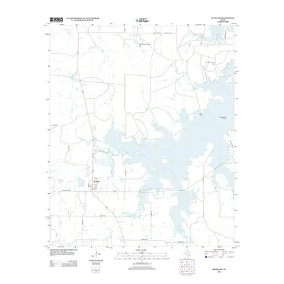
2012 Map of Scotland
USGS Topo · Published 2012About this map
Scotland sits at the intersection of local routes like FM-172 and Avenue I, serving as a central point in this North Texas landscape dominated by the extensive waters of Lake Arrowhead. The map illustrates the significant role of the petroleum industry in Archer County, highlighting the Southvogtsberger-Strawn Oil Field and the Clay County Regular Oil Field to the northeast. The Little Wichita River feeds into the reservoir, creating complex shorelines and inlets such as Horseshoe Bend. Smaller water bodies like Scotland Lake and Medders Lakes are scattered across the terrain, which is also defined by seasonal drainages including W Little Post Oak Cr and Onion Ck. A network of local ranch and farm roads, such as Dairy Rd and Mingle Hills Rd, connects the township to outlying properties like the Birdwell Ranch.
Find a feature on this map
33 named features on this map. Tap any name to fly to it.
Don’t see what you’re looking for? This feature index may not catch every label — zoom into the map to look around manually.
Map Details
Editions of this 2012 Scotland Map
This is the sole edition of this map. No revisions or reprints were ever made.
Other maps of this area

1931 · Archer City
USGS Topo · 1:62,500

1954 · Wichita Falls
USGS Topo · 1:250,000

1956 · Sloop Creek
USGS Topo · 1:24,000

1956 · Lake Wichita
USGS Topo · 1:24,000

1957 · Wichita Falls East
USGS Topo · 1:62,500

1957 · Wichita Falls West
USGS Topo · 1:62,500

1958 · Wichita Falls
USGS Topo · 1:250,000

1962 · Windthorst
USGS Topo · 1:24,000

1963 · Deer Creek
USGS Topo · 1:24,000

1963 · Scotland
USGS Topo · 1:24,000