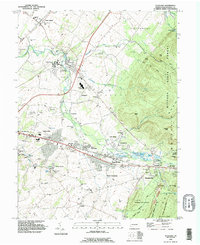
1990 Map of Scotland
USGS Topo · Published 1995About this map
Conococheague Creek snakes through the heart of this Franklin County landscape, linking a string of historic villages from Green Village in the north through Scotland and down toward Fayetteville. The map captures a moment of established community growth in the early 1990s, where traditional rural landmarks like the Scotland School for Veterans Children and several country churches, including Mt Pleasant Ch and New Guilford Ch, stand alongside emerging suburban developments. To the east, the terrain rises sharply into the dense Michaux State Forest, where features like Eagle Rock and Stony Knob overlook the valley. This contrast between the industrial and commercial activity along the main roads, marked by the Interchange 8 corridor, and the preserved wilderness of Caledonia State Park illustrates the dual character of the region's mid-century expansion and environmental heritage.
Find a feature on this map
85 named features on this map. Tap any name to fly to it.
Don’t see what you’re looking for? This feature index may not catch every label — zoom into the map to look around manually.
Map Details
Editions of this 1990 Scotland Map
This is the sole edition of this map. No revisions or reprints were ever made.
Other maps of this area

1902 · Chambersburg
USGS Topo · 1:62,500

1909 · Fairfield
USGS Topo · 1:62,500

1919 · Newville
USGS Topo · 1:62,500

1923 · Shippensburg
USGS Topo · 1:62,500

1942 · Hagerstown
USGS Topo · 1:125,000

1942 · Gettysburg
USGS Topo · 1:125,000

1943 · Hagerstown
USGS Topo · 1:125,000

1943 · Chambersburg
USGS Topo · 1:62,500

1943 · Shippensburg
USGS Topo · 1:62,500

1944 · Scotland
USGS Topo · 1:31,680
Featured Places
- Chambersburg, PA
- Fayetteville, Greene Township
- Guilford Township, PA
- Scotland, Greene Township
- Greene Township, PA