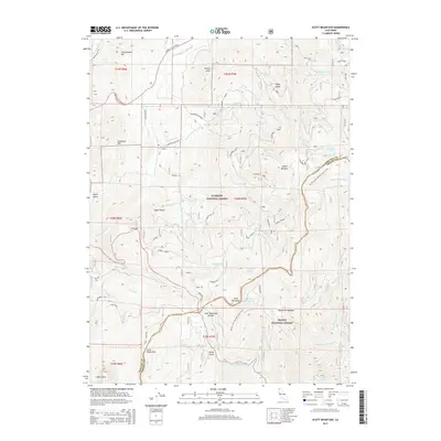
2015 Map of Scott Mountain
USGS Topo · Published 2015About this map
Klamath National Forest and Shasta National Forest meet along the high ridges of the Scott Mountains, where the 2015 landscape is defined by its industrial history and alpine hydrology. The presence of Scott Mill, Big Mill, and Black Mill along the lower slopes points to the historical timber and milling operations that once utilized these mountain drainages. Higher elevations are marked by glacial features and high-altitude water sources, including Kangaroo Lake, Lily Pad Lake, and the remote Big Carmen Lake. The Pacific Crest National Scenic Trail traverses the spine of the range, crossing near Scott Mountain Summit and providing access to this high country. Farther north, the terrain transitions into the namesake Noyes Valley and Kangaroo Pastures, revealing a landscape shaped by both the Trinity River headwaters and the E Fork Scott River system.
Find a feature on this map
57 named features on this map. Tap any name to fly to it.
Don’t see what you’re looking for? This feature index may not catch every label — zoom into the map to look around manually.
Map Details
Editions of this 2015 Scott Mountain Map
This is the sole edition of this map. No revisions or reprints were ever made.
Other maps of this area

1886 · Shasta
USGS Topo · 1:250,000

1894 · Shasta
USGS Topo · 1:250,000

1923 · Sawyers Bar
USGS Topo · 1:125,000

1931 · Etna
USGS Topo · 1:96,000

1934 · Etna
USGS Topo · 1:125,000

1948 · Weed
USGS Topo · 1:250,000

1950 · Weed
USGS Topo · 1:250,000
1955 · Bonanza King
USGS Topo · 1:62,500
1955 · China Mountain
USGS Topo · 1:62,500

1955 · Etna
USGS Topo · 1:62,500