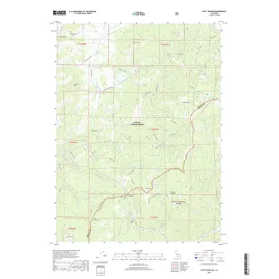
2018 Map of Scott Mountain
USGS Topo · Published 2018About this map
Scott Mountain Summit serves as a prominent landmark along the boundary of Klamath National Forest and Shasta National Forest. This high-elevation terrain is defined by the headwaters of several major drainage systems, including the E Fork Scott River and the Trinity River. The landscape is etched by the Pacific Crest National Scenic Trail, which traverses the ridge lines near Scott Mtn and Kangaroo Lake. Historical land use is evidenced by a Mine Claim in Hayes Gulch and the naming of Schoolhouse Hill in the north. The area's hydrology is particularly complex, featuring high-altitude water bodies such as Lily Pad Lake and Big Carmen Lake, alongside numerous seasonal creeks like Mule Cr and Robbers Meadow Cr that flow through the surrounding gulches and meadows.
Find a feature on this map
59 named features on this map. Tap any name to fly to it.
Don’t see what you’re looking for? This feature index may not catch every label — zoom into the map to look around manually.
Map Details
Editions of this 2018 Scott Mountain Map
This is the sole edition of this map. No revisions or reprints were ever made.
Other maps of this area

1886 · Shasta
USGS Topo · 1:250,000

1894 · Shasta
USGS Topo · 1:250,000

1923 · Sawyers Bar
USGS Topo · 1:125,000

1931 · Etna
USGS Topo · 1:96,000

1934 · Etna
USGS Topo · 1:125,000

1948 · Weed
USGS Topo · 1:250,000

1950 · Weed
USGS Topo · 1:250,000
1955 · Bonanza King
USGS Topo · 1:62,500
1955 · China Mountain
USGS Topo · 1:62,500

1955 · Etna
USGS Topo · 1:62,500