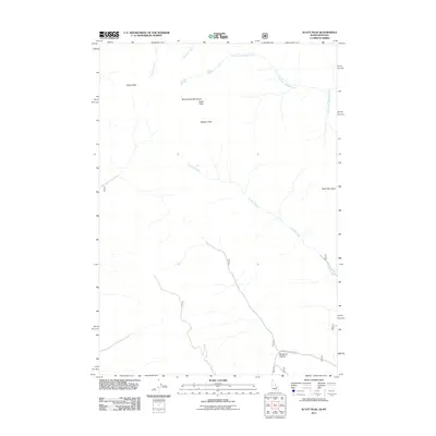
2011 Map of Scott Peak
USGS Topo · Published 2011About this map
Beaverhead Mountains define the high-altitude topography of this borderland, where the continental divide separates the high peaks of the northern Rockies. The landscape is dominated by massive formations such as Italian Peak, Scott Peak, and Webber Peak, illustrating a primitive mountain environment defined by drainage patterns rather than human settlement. A network of alpine waterways, including Nicholia Creek and Crooked Creek, carves through the rocky terrain, showing the natural path of snowmelt and runoff. The only significant infrastructure shown is Buckhorn Canyon Rd, which provides access to the southern reaches near Buckhorn Canyon. This 2011 survey captures the area in a state of natural preservation, with remote landmarks like Heart Mountain standing as permanent fixtures in this sparsely populated region.
Find a feature on this map
12 named features on this map. Tap any name to fly to it.
Don’t see what you’re looking for? This feature index may not catch every label — zoom into the map to look around manually.
Map Details
Editions of this 2011 Scott Peak Map
This is the sole edition of this map. No revisions or reprints were ever made.
Other maps of this area

1955 · Dubois
USGS Topo · 1:250,000

1957 · Scott Peak
USGS Topo · 1:62,500

1957 · Edie Ranch
USGS Topo · 1:62,500

1958 · Dubois
USGS Topo · 1:250,000

1969 · Shamrock Gulch
USGS Topo · 1:24,000

1969 · Copper Mtn
USGS Topo · 1:24,000
1969 · Blue Dome
USGS Topo · 1:24,000

1983 · Dubois
USGS Topo · 1:100,000
1987 · Eighteenmile Peak
USGS Topo · 1:24,000
1987 · Deadman Lake
USGS Topo · 1:24,000