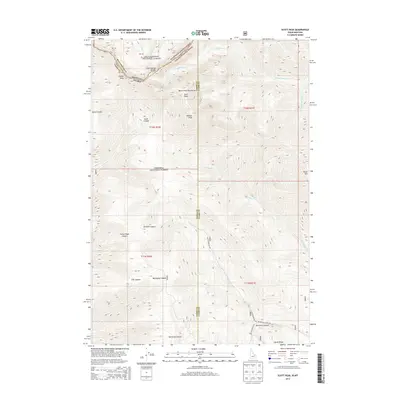
2013 Map of Scott Peak
USGS Topo · Published 2013About this map
The Continental Divide serves as the high-altitude spine of this survey, marking the jagged boundary between Beaverhead Co and Lemhi Co. This section of the Beaverhead Mountains contains several prominent summits, including the namesake Scott Peak, Webber Peak, and the tri-state point near Italian Peak. The landscape is a complex network of drainage basins and canyons that spill away from the divide into both the Beaverhead National Forest and the Targhee National Forest.
Find a feature on this map
34 named features on this map. Tap any name to fly to it.
Don’t see what you’re looking for? This feature index may not catch every label — zoom into the map to look around manually.
Map Details
Editions of this 2013 Scott Peak Map
This is the sole edition of this map. No revisions or reprints were ever made.
Other maps of this area

1955 · Dubois
USGS Topo · 1:250,000

1957 · Scott Peak
USGS Topo · 1:62,500

1957 · Edie Ranch
USGS Topo · 1:62,500

1958 · Dubois
USGS Topo · 1:250,000

1969 · Shamrock Gulch
USGS Topo · 1:24,000

1969 · Copper Mtn
USGS Topo · 1:24,000
1969 · Blue Dome
USGS Topo · 1:24,000

1983 · Dubois
USGS Topo · 1:100,000
1987 · Eighteenmile Peak
USGS Topo · 1:24,000
1987 · Deadman Lake
USGS Topo · 1:24,000