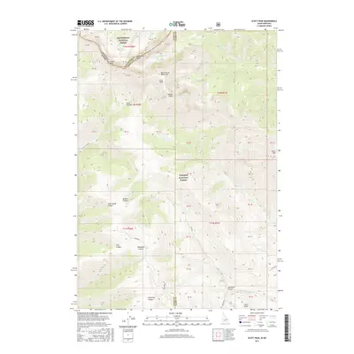
2017 Map of Scott Peak
USGS Topo · Published 2017About this map
The Continental Divide defines the spine of this high-elevation landscape, where the Beaverhead Mountains straddle the jurisdictional boundary between Montana and Idaho. Dominating the central heights is Scott Peak, flanked by Webber Peak and the rugged drainage of Scott Canyon. This 2017 survey details a remote wilderness managed within the Beaverhead National Forest and Targhee National Forest. The map documents a complex system of canyons and ridges, including the deep cuts of Nicholia Canyon and Indian Head Canyon. Significant topographical markers like Italian Peak on the northern border and Heart Mtn to the east provide essential reference points for navigating this high-country terrain. Natural watercourses such as Deadman Cr and Crooked Cr carve through the mountain slopes, illustrating the hydrology of the upper basins near Slate Basin.
Find a feature on this map
29 named features on this map. Tap any name to fly to it.
Don’t see what you’re looking for? This feature index may not catch every label — zoom into the map to look around manually.
Map Details
Editions of this 2017 Scott Peak Map
This is the sole edition of this map. No revisions or reprints were ever made.
Other maps of this area

1955 · Dubois
USGS Topo · 1:250,000

1957 · Scott Peak
USGS Topo · 1:62,500

1957 · Edie Ranch
USGS Topo · 1:62,500

1958 · Dubois
USGS Topo · 1:250,000

1969 · Shamrock Gulch
USGS Topo · 1:24,000

1969 · Copper Mtn
USGS Topo · 1:24,000
1969 · Blue Dome
USGS Topo · 1:24,000

1983 · Dubois
USGS Topo · 1:100,000
1987 · Eighteenmile Peak
USGS Topo · 1:24,000
1987 · Deadman Lake
USGS Topo · 1:24,000