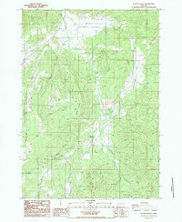
1987 Map of Scotts Valley
USGS Topo · Published 1987About this map
Elkhead Mines and the nearby community of Elkhead define the central drainage of this 1987 survey, where resource extraction and timber-ready terrain intersect at the Douglas and Lane county line. The landscape is characterized by the prominent rises of Dickinson Mountain and Beth Moore Mountain, which channel numerous waterways including Elk Creek and Shingle Mill Creek. Small settlements like Bennet sit within the namesake Scotts Valley, while the eastern edge of the map opens into the distinct Shoestring Valley. This provisional edition captures a network of resource roads and quarries, illustrating the industrial footprint on the Pacific Northwest backcountry during the late twentieth century. Numerous family-named landmarks such as Adams Creek and Wilson Creek suggest the long-standing rural ties to these drainages.
Find a feature on this map
19 named features on this map. Tap any name to fly to it.
Don’t see what you’re looking for? This feature index may not catch every label — zoom into the map to look around manually.
Map Details
Editions of this 1987 Scotts Valley Map
This is the sole edition of this map. No revisions or reprints were ever made.
Other maps of this area

1897 · Roseburg
USGS Topo · 1:125,000

1900 · Roseburg
USGS Topo · 1:125,000

1954 · Sutherlin
USGS Topo · 1:62,500

1954 · Drain
USGS Topo · 1:62,500

1954 · Anlauf
USGS Topo · 1:62,500

1954 · Glide
USGS Topo · 1:62,500

1958 · Roseburg
USGS Topo · 1:250,000

1959 · Roseburg
USGS Topo · 1:250,000

1979 · Roseburg
USGS Topo · 1:100,000

1979 · Cottage Grove
USGS Topo · 1:100,000