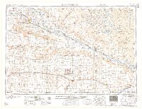
1958 Map of Scottsbluff
USGS Topo · Published 1958About this map
Scotts Bluff National Monument and the iconic spire of Chimney Rock anchor this survey of the Nebraska Panhandle, tracing the historic corridor of the North Platte River. The map captures a landscape defined by dramatic geological landmarks like the Wildcat Hills and Signal Butte, alongside the complex irrigation and rail systems that supported early 20th-century agriculture. Two major railroads, the Union Pacific and the Chicago Burlington & Quincy, parallel the river and southern border, connecting established towns like Scottsbluff, Sidney, and Bridgeport.
Find a feature on this map
151 named features on this map. Tap any name to fly to it.
Don’t see what you’re looking for? This feature index may not catch every label — zoom into the map to look around manually.
Map Details
Editions of this 1958 Scottsbluff Map
2 editions found

Other maps of this area

1896 · Patrick
USGS Topo · 1:125,000

1896 · Browns Creek
USGS Topo · 1:125,000

1897 · Ogallala
USGS Topo · 1:125,000

1898 · Scotts Bluff
USGS Topo · 1:125,000

1898 · Camp Clarke
USGS Topo · 1:125,000

1899 · Browns Creek
USGS Topo · 1:125,000

1899 · Sidney
USGS Topo · 1:125,000

1899 · Goshen Hole
USGS Topo · 1:125,000

1899 · Whistle Creek
USGS Topo · 1:125,000

1900 · Chappell
USGS Topo · 1:125,000