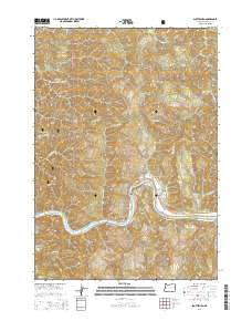
2014 Map of Scottsburg
USGS Topo · Published 2014About this map
The Umpqua River winds through the heart of this Douglas County landscape, serving as the central artery for the historic settlement of Scottsburg. This community is situated at a key bend in the river, where Pacific St and Main St meet the shoreline. The surrounding terrain is defined by steep ridges and dense woodlands, much of it contained within the Siuslaw National Forest. Notable elevations like Golden Ridge, Fern Top, and Franklin Ridge overlook a complex network of drainages including Wasson Cr and Mill Creek. Genealogists and local historians can locate the Scottsburg Cem perched above the river near the settlement of Green Acres. The map also documents the river's character, highlighting features like Rock Island and the entry of numerous tributaries such as Vincent Cr and Burchard Cr.
Find a feature on this map
37 named features on this map. Tap any name to fly to it.
Don’t see what you’re looking for? This feature index may not catch every label — zoom into the map to look around manually.
Map Details
Editions of this 2014 Scottsburg Map
This is the sole edition of this map. No revisions or reprints were ever made.
Other maps of this area

1919 · Earl
USGS Topo · 1:48,000

1942 · Roman Nose Mtn
USGS Topo · 1:62,500

1943 · Goodwin Peak
USGS Topo · 1:62,500

1945 · Roman Nose Mtn
USGS Topo · 1:62,500

1955 · Scottsburg
USGS Topo · 1:62,500

1955 · Elkton
USGS Topo · 1:62,500
1956 · Goodwin Peak
USGS Topo · 1:62,500

1958 · Roseburg
USGS Topo · 1:250,000

1959 · Roseburg
USGS Topo · 1:250,000

1979 · Cottage Grove
USGS Topo · 1:100,000