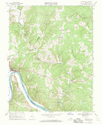
1967 Map of Scottsville
USGS Topo · Published 1969About this map
The James River carves a dramatic path through this central Virginia landscape, creating the prominent Horseshoe Bend and Muleshoe Bend where the boundaries of Albemarle, Fluvanna, and Buckingham counties converge. The town of Scottsville serves as the focal point, situated at a vital river bend where the Chesapeake and Ohio River railroad tracks follow the northern bank. This era shows a community rooted in its geographic advantages, featuring industry and infrastructure such as the Jefferson Mill on the Hardware River and several Quarrys near the riverbank.
Find a feature on this map
36 named features on this map. Tap any name to fly to it.
Don’t see what you’re looking for? This feature index may not catch every label — zoom into the map to look around manually.
Map Details
Editions of this 1967 Scottsville Map
2 editions found
Other maps of this area

1891 · Palmyra
USGS Topo · 1:125,000

1892 · Buckingham
USGS Topo · 1:125,000

1895 · Palmyra
USGS Topo · 1:125,000

1897 · Palmyra
USGS Topo · 1:125,000

1929 · Covesville
USGS Topo · 1:62,500

1935 · Covesville
USGS Topo · 1:62,500

1943 · Scottsville
USGS Topo · 1:62,500

1945 · Covesville
USGS Topo · 1:62,500

1946 · Scottsville
USGS Topo · 1:62,500

1947 · Roanoke
USGS Topo · 1:250,000