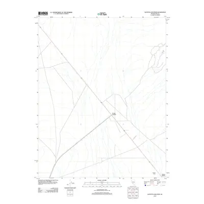
2012 Map of Scottys Junction
USGS Topo · Published 2012About this map
Scottys Junction serves as the central hub of this desert landscape in Nye County, where the convergence of major travel routes dictates the area's layout. This 2012 survey captures a remote Nevada crossroads where Highway 95 meets State Route 267, a junction historically vital for transit through the arid basins. Outside of the primary intersection, the map reveals specific named locales such as Coyote Holes and Farmer Station, which hint at the region's sparse but localized activity. The terrain is marked by a network of unimproved paths and desert tracks, including Creech Rd and Cat Trl, illustrating how long-distance thoroughfares and local service roads interact in this corner of the Great Basin.
Find a feature on this map
7 named features on this map. Tap any name to fly to it.
Don’t see what you’re looking for? This feature index may not catch every label — zoom into the map to look around manually.
Map Details
Editions of this 2012 Scottys Junction Map
This is the sole edition of this map. No revisions or reprints were ever made.
Other maps of this area

1908 · Kawich
USGS Topo · 1:250,000

1908 · Lida
USGS Topo · 1:250,000

1913 · Lida
USGS Topo · 1:250,000

1942 · Tolicha Peak
USGS Topo · 1:125,000

1954 · Goldfield
USGS Topo · 1:250,000

1955 · Goldfield
USGS Topo · 1:250,000

1958 · Goldfield
USGS Topo · 1:250,000

1962 · Goldfield
USGS Topo · 1:250,000
1966 · Springdale
USGS Topo · 1:62,500

1968 · Stonewall Pass
USGS Topo · 1:24,000