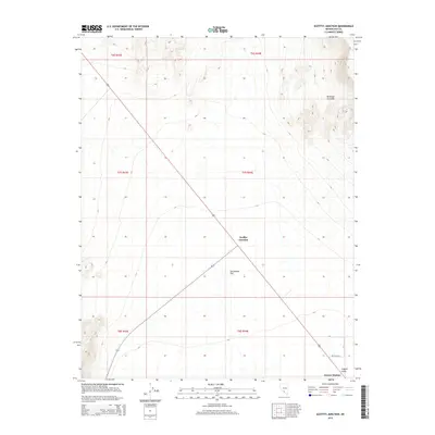
2015 Map of Scottys Junction
USGS Topo · Published 2015About this map
Scottys Junction serves as the primary crossroads in this high desert landscape, where regional thoroughfares intersect amidst the broad expanse of Sarcobatus Flat. The map reveals a sparse but deliberate network of local roads in the southeast, including the uniquely named Petticoat Ln, N St, and E St near the settlement of Farmer Station. This concentration of small-scale infrastructure suggests a pocket of habitation or ranching activity distinct from the open terrain to the west. To the south, Coyote Holes provides a rare named water feature, indicating a point of interest in an otherwise arid environment. The layout of these features demonstrates how early 21st-century desert settlements continue to cluster around key transit points and reliable local landmarks.
Find a feature on this map
13 named features on this map. Tap any name to fly to it.
Don’t see what you’re looking for? This feature index may not catch every label — zoom into the map to look around manually.
Map Details
Editions of this 2015 Scottys Junction Map
This is the sole edition of this map. No revisions or reprints were ever made.
Other maps of this area

1908 · Kawich
USGS Topo · 1:250,000

1908 · Lida
USGS Topo · 1:250,000

1913 · Lida
USGS Topo · 1:250,000

1942 · Tolicha Peak
USGS Topo · 1:125,000

1954 · Goldfield
USGS Topo · 1:250,000

1955 · Goldfield
USGS Topo · 1:250,000

1958 · Goldfield
USGS Topo · 1:250,000

1962 · Goldfield
USGS Topo · 1:250,000
1966 · Springdale
USGS Topo · 1:62,500

1968 · Stonewall Pass
USGS Topo · 1:24,000