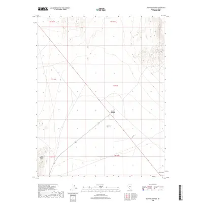
2018 Map of Scottys Junction
USGS Topo · Published 2018About this map
Scottys Junction serves as the focal point for this desert landscape in southern Nye County, where the desert floor of Sarcobatus Flat meets the rising terrain of the Gold Mountain Range to the west. This mapping of the Great Basin terrain illustrates a critical transportation hub where Route 95 intersects with State Route 72 267, providing a waypoint for travelers and a study of modern infrastructure in an arid environment. The map details natural landforms like Coyote Holes in the southeast corner and follows the path of Creech Rd through the alluvial fans. This survey highlights the precise township and range grids, including t7s r44e, which define the administrative boundaries and land divisions of this high-desert region during the late twenty-first century.
Find a feature on this map
13 named features on this map. Tap any name to fly to it.
Don’t see what you’re looking for? This feature index may not catch every label — zoom into the map to look around manually.
Map Details
Editions of this 2018 Scottys Junction Map
This is the sole edition of this map. No revisions or reprints were ever made.
Other maps of this area

1908 · Kawich
USGS Topo · 1:250,000

1908 · Lida
USGS Topo · 1:250,000

1913 · Lida
USGS Topo · 1:250,000

1942 · Tolicha Peak
USGS Topo · 1:125,000

1954 · Goldfield
USGS Topo · 1:250,000

1955 · Goldfield
USGS Topo · 1:250,000

1958 · Goldfield
USGS Topo · 1:250,000

1962 · Goldfield
USGS Topo · 1:250,000
1966 · Springdale
USGS Topo · 1:62,500

1968 · Stonewall Pass
USGS Topo · 1:24,000