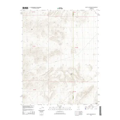
2014 Map of Scottys Junction SW
USGS Topo · Published 2014About this map
Slate Ridge dominates the northwestern portion of this 2014 survey, a high-relief landscape that reveals the geological complexity of the Great Basin. The terrain transitions south and east into the Gold Mountain Range and the northern reaches of the Amargosa Range, illustrating the characteristic basin-and-range topography where steep ridges fall away into wide, high-altitude desert valleys. The county line between Esmeralda and Nye counties bisects the eastern half of the map, providing a administrative context to this sparsely populated region. Human activity is evidenced by the Cat Trl, a route winding through the southwestern quadrant near Hells Gate. This topographic study is particularly valuable for understanding the drainage patterns and relief that define the landscape north of Death Valley, offering precise data on the natural contours before any recent anthropogenic changes to the local trail network.
Find a feature on this map
6 named features on this map. Tap any name to fly to it.
Don’t see what you’re looking for? This feature index may not catch every label — zoom into the map to look around manually.
Map Details
Editions of this 2014 Scottys Junction SW Map
This is the sole edition of this map. No revisions or reprints were ever made.
Other maps of this area

1908 · Lida
USGS Topo · 1:250,000

1913 · Lida
USGS Topo · 1:250,000

1954 · Goldfield
USGS Topo · 1:250,000

1955 · Goldfield
USGS Topo · 1:250,000

1957 · Ubehebe Crater
USGS Topo · 1:62,500

1958 · Goldfield
USGS Topo · 1:250,000

1962 · Goldfield
USGS Topo · 1:250,000

1968 · Stonewall Pass
USGS Topo · 1:24,000
1968 · Bonnie Claire NW
USGS Topo · 1:24,000
1968 · Gold Point
USGS Topo · 1:24,000