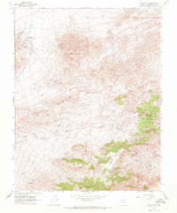
1968 Map of Gold Point
USGS Topo · Published 1970About this map
The high-desert mining landscape of Slate Ridge and Gold Mountain dominates this late-1960s survey of southern Esmeralda County. The area’s extractive history is etched into the terrain, centered on the settlement of Gold Point and the numerous workings scattered across the slopes, including the Dunfee Shaft, Alberta Mine, and Empress Mine. These sites, linked by a network of jeep trails and pack trails, reflect the persistent search for minerals in this arid corner of Nevada.
Find a feature on this map
28 named features on this map. Tap any name to fly to it.
Don’t see what you’re looking for? This feature index may not catch every label — zoom into the map to look around manually.
Map Details
Editions of this 1968 Gold Point Map
2 editions found
Other maps of this area

1908 · Lida
USGS Topo · 1:250,000

1913 · Lida
USGS Topo · 1:250,000

1954 · Goldfield
USGS Topo · 1:250,000

1955 · Goldfield
USGS Topo · 1:250,000

1957 · Ubehebe Crater
USGS Topo · 1:62,500

1958 · Goldfield
USGS Topo · 1:250,000

1962 · Goldfield
USGS Topo · 1:250,000

1968 · Lida
USGS Topo · 1:24,000

1968 · Stonewall Pass
USGS Topo · 1:24,000
1968 · Gold Point SW
USGS Topo · 1:24,000