
1968 Map of Lida
USGS Topo · Published 1970About this map
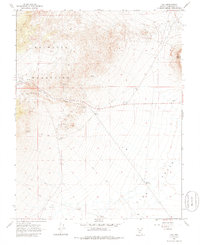
Lida serves as the focal point for this 1960s survey of high-desert terrain in Esmeralda County. Located at the foot of the Palmetto Mountains, this small settlement is surrounded by evidence of early industrial and transit activity, including a Water Tank and a local Cem. The landscape is defined by the sharp transition from the mountainous peaks down through Lida Canyon into the expansive Lida Valley. Local resource extraction and water management are visible through markers for a Prospect, several Borrow Pit locations, and the Pipeline Reservoir. For genealogists and local historians, the inclusion of Stewarts Mill (Site) and Stewarts Spring provides specific names tied to the historical land use and early development of this arid region.
Find a feature on this map
21 named features on this map. Tap any name to fly to it.
Don’t see what you’re looking for? This feature index may not catch every label — zoom into the map to look around manually.
Map Details
Editions of this 1968 Lida Map
2 editions found
Other maps of this area

1898 · Silver Peak
USGS Topo · 1:125,000

1900 · Silver Peak
USGS Topo · 1:125,000

1908 · Lida
USGS Topo · 1:250,000

1913 · Lida
USGS Topo · 1:250,000

1945 · Goldfield
USGS Topo · 1:125,000

1954 · Goldfield
USGS Topo · 1:250,000

1955 · Goldfield
USGS Topo · 1:250,000

1957 · Magruder Mtn
USGS Topo · 1:62,500

1958 · Goldfield
USGS Topo · 1:250,000

1962 · Goldfield
USGS Topo · 1:250,000