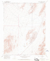
1968 Map of Bonnie Claire NW
USGS Topo · Published 1970About this map
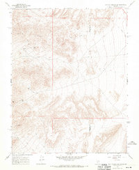
Bonnie Claire Flat dominates the center of this high-desert landscape on the border of Esmeralda County and Nye County. The 1968 topography captures a remote region defined by ephemeral basins and industrial traces, notably the Old RR Grade cutting through the eastern corridor. Transportation history is further marked by the Bonnie Claire Airport and a series of rugged paths like the Jeep Trail. To the south, the terrain rises sharply into the Grapevine Mountains, overlooking the vast Bonnie Claire Lake bed and the adjacent Landing Strip Depression. This survey provides a precise record of the Great Basin’s desert-floor hydrology and the remnants of early twentieth-century rail infrastructure that once served this isolated corner of Nevada.
Find a feature on this map
10 named features on this map. Tap any name to fly to it.
Don’t see what you’re looking for? This feature index may not catch every label — zoom into the map to look around manually.
Map Details
Editions of this 1968 Bonnie Claire NW Map
2 editions found
Other maps of this area

1908 · Lida
USGS Topo · 1:250,000

1913 · Lida
USGS Topo · 1:250,000

1954 · Goldfield
USGS Topo · 1:250,000

1955 · Goldfield
USGS Topo · 1:250,000

1957 · Ubehebe Crater
USGS Topo · 1:62,500

1958 · Goldfield
USGS Topo · 1:250,000

1962 · Goldfield
USGS Topo · 1:250,000
1967 · Bonnie Claire SE
USGS Topo · 1:24,000
1968 · Gold Point
USGS Topo · 1:24,000
1968 · Scottys Junction SW
USGS Topo · 1:24,000