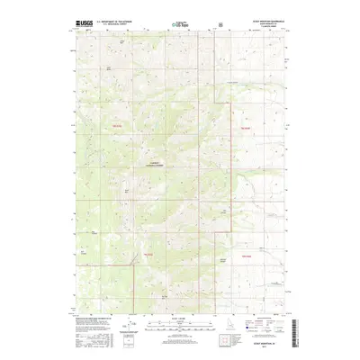
2017 Map of Scout Mountain
USGS Topo · Published 2017About this map
Caribou National Forest dominates this section of the Portneuf Range in Bannock County, defined by a complex network of drainages and high peaks. The topography is anchored by Scout Mountain and Old Tom Mountain, with the surrounding landscape carved by numerous canyons such as Mormon Canyon and Box Canyon. A series of mountain roads, including Scout Mountain Top Rd and W Goodenough Rd, provide access through the dense contour lines of the forest. The drainage patterns are clearly established by several named waterways, notably Goodenough Creek, Bell Marsh Creek, and Cottonwood Creek. To the north, Indian Mountain rises above the Lead Draw and Indian Creek, illustrating the high-elevation terrain that characterizes this part of southeastern Idaho.
Find a feature on this map
27 named features on this map. Tap any name to fly to it.
Don’t see what you’re looking for? This feature index may not catch every label — zoom into the map to look around manually.
Map Details
Editions of this 2017 Scout Mountain Map
This is the sole edition of this map. No revisions or reprints were ever made.
Other maps of this area

1937 · Pocatello
USGS Topo · 1:48,000

1944 · Pocatello
USGS Topo · 1:62,500

1954 · Pocatello
USGS Topo · 1:250,000

1958 · Pocatello
USGS Topo · 1:250,000

1968 · Hawkins
USGS Topo · 1:24,000

1968 · Clifton Creek
USGS Topo · 1:24,000
1968 · Arimo
USGS Topo · 1:24,000
1968 · Bonneville Peak
USGS Topo · 1:24,000

1968 · Bradley Mtn
USGS Topo · 1:24,000

1968 · Mc Cammon
USGS Topo · 1:24,000