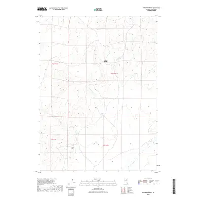
2018 Map of Scraper Springs
USGS Topo · Published 2018About this map
Scraper Springs serves as a primary geographic anchor in this remote stretch of Elko County, where the high desert landscape is defined by its seasonal hydrology and sparse pastoral footprints. This topographic survey captures a quiet segment of the Great Basin during the late 2010s, emphasizing the distribution of vital water sources such as Buffalo Springs and the drainage patterns of Buffalo Cr and Scraper Springs Cr. To the south, Frazer Field indicates a pockets of human activity or grazing territory situated near the headwaters of Frazer Cr. The map illustrates a strictly rectilinear Public Land Survey System grid, which imposes order over the undulating contours of the high plateau, revealing how property lines and range management boundaries were traditionally structured in the absence of dense modern infrastructure.
Find a feature on this map
10 named features on this map. Tap any name to fly to it.
Don’t see what you’re looking for? This feature index may not catch every label — zoom into the map to look around manually.
Map Details
Editions of this 2018 Scraper Springs Map
This is the sole edition of this map. No revisions or reprints were ever made.
Other maps of this area

1955 · McDermitt
USGS Topo · 1:250,000

1959 · McDermitt
USGS Topo · 1:250,000

1965 · Willow Creek Reservoir
USGS Topo · 1:24,000

1965 · Squaw Valley Ranch
USGS Topo · 1:24,000
1965 · Midas
USGS Topo · 1:24,000

1973 · Haystack Peak
USGS Topo · 1:24,000

1973 · Little Rock Creek
USGS Topo · 1:24,000

1974 · Soldier Cap
USGS Topo · 1:24,000

1974 · Burner Hills
USGS Topo · 1:24,000

1977 · Scraper Springs
USGS Topo · 1:24,000