
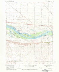
1966 Map of Scribner SW
USGS Topo · Published 1967About this map
Scribner State Airfield anchors the northeast corner of this mid-1960s survey, its expansive perimeter clearly defined by an Airfield Boundary. The surrounding terrain is organized into the rural townships of Ridgeley, Everett, Cotterell, and Maple, showcasing the characteristic Nebraska section-line road grid. Three primary watercourses—Silver Creek, Maple Creek, and Rawhide Creek—meander through the landscape, their winding paths contrasting with the rigid geometry of the agricultural plots. For genealogists and local historians, the map identifies specific community focal points such as St Johns Ch, St Marys Cem, and Maple Grove Cem. The distribution of rural education is preserved through the locations of several district buildings, including School No 90, School No 12, School No 22, and School No 93, providing a record of the area's social infrastructure before the consolidation of many small country districts.
Find a feature on this map
17 named features on this map. Tap any name to fly to it.
Don’t see what you’re looking for? This feature index may not catch every label — zoom into the map to look around manually.
Map Details
Editions of this 1966 Scribner SW Map
This is the sole edition of this map. No revisions or reprints were ever made.
Other maps of this area

1899 · Wahoo
USGS Topo · 1:125,000

1955 · Fremont
USGS Topo · 1:250,000

1957 · Fremont
USGS Topo · 1:250,000

1958 · Fremont
USGS Topo · 1:250,000

1966 · Uehling
USGS Topo · 1:24,000

1966 · Webster
USGS Topo · 1:24,000

1966 · Hooper
USGS Topo · 1:24,000

1966 · Snyder
USGS Topo · 1:24,000

1966 · Scribner
USGS Topo · 1:24,000
1968 · Malmo NW
USGS Topo · 1:24,000