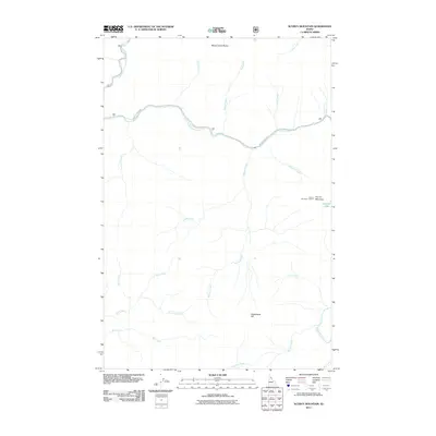
2011 Map of Scurvy Mountain
USGS Topo · Published 2011About this map
Scurvy Mountain Lookout stands as a prominent high point in this backcountry region of Idaho, surveying a landscape defined by high ridges and a dense network of watercourses. The drainage patterns of the area are centered around the North Fork Clearwater River and the significant Kelly Creek, which are fed by numerous smaller streams such as Slippery Creek and Paradise Creek. Evidence of high-altitude navigation is found along Moose Creek Rd as it winds through the northern terrain near Moose Creek Buttes. The elevation profile is further detailed by landmarks like Switchback Hill and Scurvy Mountain, while the presence of Scurvy Lake provides a notable riparian feature amidst the steep geography. This 2011 survey by the U.S. Geological Survey captures the remote character of the Clearwater National Forest area through its hydrographic and topographic detail.
Find a feature on this map
26 named features on this map. Tap any name to fly to it.
Don’t see what you’re looking for? This feature index may not catch every label — zoom into the map to look around manually.
Map Details
Editions of this 2011 Scurvy Mountain Map
This is the sole edition of this map. No revisions or reprints were ever made.
Other maps of this area

1911 · Lolo
USGS Topo · 1:250,000

1913 · Lolo
USGS Topo · 1:250,000

1956 · Hamilton
USGS Topo · 1:250,000

1959 · Hamilton
USGS Topo · 1:250,000

1960 · Hamilton
USGS Topo · 1:250,000
1963 · Elizabeth Lake
USGS Topo · 1:24,000

1964 · Hamilton
USGS Topo · 1:250,000

1965 · Osier Ridge
USGS Topo · 1:24,000

1965 · Junction Mtn
USGS Topo · 1:24,000
1965 · Moose Mtn
USGS Topo · 1:24,000