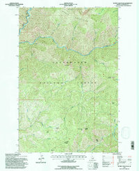
1994 Map of Scurvy Mountain
USGS Topo · Published 1997About this map
Clearwater National Forest dominates this landscape, where the North Fork Clearwater River and Kelly Creek carve deep through high-elevation terrain. This mid-1990s survey preserves the administrative and access network of the U.S. Forest Service, highlighting essential backcountry infrastructure such as the Junction Creek Pack Bridge and the Scurvy Lookout atop Scurvy Mountain. The map detail reveals a specialized lexicon of the Idaho wilderness, from the open expanses of Paradise Meadows and Pony Flats to the steep relief of the Moose Mountains and Moose Buttes. Water resources are central to this area's geography, with countless drainages like Canyon Creek, Slippery Creek, and Barnard Creek feeding into the larger river systems. For researchers, these labels reflect a history of forest management and backcountry travel, marking high-country crossings such as Scurvy Saddle and Windy Bill Saddle.
Find a feature on this map
33 named features on this map. Tap any name to fly to it.
Don’t see what you’re looking for? This feature index may not catch every label — zoom into the map to look around manually.
Map Details
Editions of this 1994 Scurvy Mountain Map
This is the sole edition of this map. No revisions or reprints were ever made.
Other maps of this area

1911 · Lolo
USGS Topo · 1:250,000

1913 · Lolo
USGS Topo · 1:250,000

1956 · Hamilton
USGS Topo · 1:250,000

1959 · Hamilton
USGS Topo · 1:250,000

1960 · Hamilton
USGS Topo · 1:250,000
1963 · Elizabeth Lake
USGS Topo · 1:24,000

1964 · Hamilton
USGS Topo · 1:250,000

1965 · Osier Ridge
USGS Topo · 1:24,000

1965 · Junction Mtn
USGS Topo · 1:24,000
1965 · Moose Mtn
USGS Topo · 1:24,000