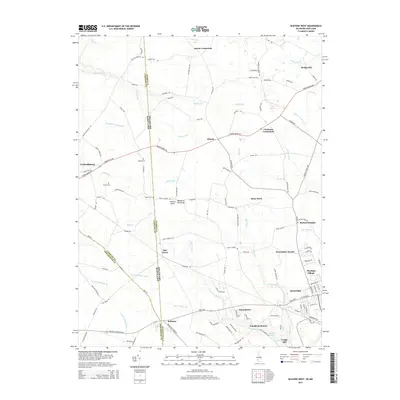
2014 Map of Seaford West
USGS Topo · Published 2014About this map
The Delaware and Maryland border defines the character of this landscape on the Delmarva Peninsula, where rural crossroads and agricultural hamlets like Atlanta and Oak Grove sit within a network of historic drainage ditches and small branches. The map highlights the western periphery of Seaford, extending toward the state line and the neighboring community of Federalsburg. Local history is visible in the placement of the Bethel Cem and Wright Cem, along with older settlement patterns near Jacobs Crossroads and Clarksons Crossroads. The southern portion of the sheet is marked by the wetlands and millponds of the Nanticoke watershed, including Craigs Pond at Craigs Mill and the slow-moving waters of Wrights Millpond Br. This 2014 survey documents the modern layout of residential areas such as Heritage Village and Devonshire Woods as they expand into the traditional woodlots and fields of Sussex County.
Find a feature on this map
128 named features on this map. Tap any name to fly to it.
Don’t see what you’re looking for? This feature index may not catch every label — zoom into the map to look around manually.
Map Details
Editions of this 2014 Seaford West Map
This is the sole edition of this map. No revisions or reprints were ever made.
Other maps of this area

1905 · Denton
USGS Topo · 1:62,500

1905 · Hurlock
USGS Topo · 1:62,500

1915 · Seaford
USGS Topo · 1:62,500

1918 · Harrington
USGS Topo · 1:62,500

1944 · Federalsburg
USGS Topo · 1:31,680

1944 · Seaford
USGS Topo · 1:62,500

1944 · Hobbs
USGS Topo · 1:31,680
1944 · Rhodesdale
USGS Topo · 1:31,680
1944 · Harrington
USGS Topo · 1:62,500

1946 · Salisbury
USGS Topo · 1:250,000