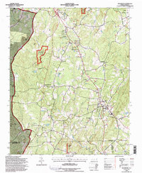
1994 Map of Seagrove
USGS Topo · Published 1996About this map
Seagrove sits at the heart of this mid-1990s landscape, serving as a crossroads where the Norfolk Southern rail line and U.S. 220 intersect. The map illustrates a rural Piedmont community deeply connected to its land and faith, evidenced by the high density of country churches such as Antioch Ch, Pisgah Ch, and Flag Springs Ch. To the west, the Uwharrie National Forest covers the terrain of Kies Mtn and Nancys Mtn, providing a stark contrast to the small-scale farming and residential patterns found at Aumans Crossroads and Michfield. Waterways like the South Prong Little River and Bachelor Creek wind through the topography, while landmarks like the State Zoological Park on the northern edge signify the region's broader recreational and conservation role. Local genealogists will find value in the specific locations of rural cemeteries and smaller settlements like Whynot.
Find a feature on this map
53 named features on this map. Tap any name to fly to it.
Don’t see what you’re looking for? This feature index may not catch every label — zoom into the map to look around manually.
Map Details
Editions of this 1994 Seagrove Map
This is the sole edition of this map. No revisions or reprints were ever made.
Other maps of this area

1942 · Troy
USGS Topo · 1:125,000

1953 · Raleigh
USGS Topo · 1:250,000

1954 · Raleigh
USGS Topo · 1:250,000

1957 · Troy
USGS Topo · 1:62,500

1957 · Asheboro
USGS Topo · 1:62,500

1968 · Ramseur
USGS Topo · 1:24,000

1968 · Erect
USGS Topo · 1:24,000

1970 · Asheboro
USGS Topo · 1:24,000
1973 · Eleazer
USGS Topo · 1:24,000

1973 · Seagrove
USGS Topo · 1:24,000