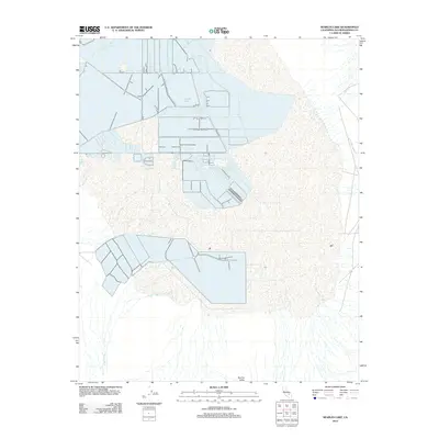
2012 Map of Searles Lake
USGS Topo · Published 2012About this map
Searles Lake dominates the upper half of this 2012 survey, revealing a landscape defined by industrial brine extraction and evaporation ponds. Located within the Searles Valley, the map shows the intricate network of dikes and canals used to manage the dry lake's mineral-rich resources. The stark transition from the complex geometry of the salt pan to the desert floor is marked by drainage features like Teagle Wash, which cuts across the southern portion of the quadrangle. This edition captures the physical footprint of chemical mining operations at the start of the 2010s, illustrating how human engineering has reshaped the natural basin floor to harvest borax and potash.
Find a feature on this map
3 named features on this map. Tap any name to fly to it.
Don’t see what you’re looking for? This feature index may not catch every label — zoom into the map to look around manually.
Map Details
Editions of this 2012 Searles Lake Map
This is the sole edition of this map. No revisions or reprints were ever made.
Other maps of this area

1915 · Searles Lake
USGS Topo · 1:250,000

1947 · Trona
USGS Topo · 1:250,000

1948 · Trona
USGS Topo · 1:250,000

1949 · Trona
USGS Topo · 1:62,500

1949 · Searles Lake
USGS Topo · 1:62,500

1950 · Searles Lake
USGS Topo · 1:62,500

1950 · Trona
USGS Topo · 1:62,500

1950 · Manly Peak
USGS Topo · 1:62,500

1950 · Wingate Pass
USGS Topo · 1:62,500

1951 · Wingate Pass
USGS Topo · 1:62,500