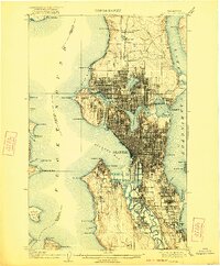
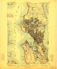
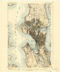
1909 Map of Seattle
USGS Topo · Published 1922About this map
Seattle dominates the landscape in this era of rapid municipal expansion, showing the city's complex relationship with its surrounding waters just after the turn of the century. The map captures a critical moment for the State University grounds as they hosted the Alaska-Yukon-Pacific Exposition, a landmark event that reshaped the local topography near Portage Bay. The dense street grid of the central business district contrasts sharply with the independent character of outlying neighborhoods like Ballard, Youngstown, and Georgetown, which still retained distinct industrial and residential identities.
Find a feature on this map
75 named features on this map. Tap any name to fly to it.
Don’t see what you’re looking for? This feature index may not catch every label — zoom into the map to look around manually.
Map Details
Editions of this 1909 Seattle Map
4 editions found
Other maps of this area

1894 · Seattle
USGS Topo · 1:62,500

1895 · Snohomish
USGS Topo · 1:125,000

1897 · Tacoma
USGS Topo · 1:125,000

1897 · Seattle
USGS Topo · 1:125,000

1900 · Tacoma
USGS Topo · 1:125,000

1908 · Seattle
USGS Topo · 1:62,500

1909 · Seattle Special
USGS Topo · 1:62,500

1937 · Port Orchard
USGS Topo · 1:62,500

1937 · Port Gamble
USGS Topo · 1:62,500

1940 · Port Gamble
USGS Topo · 1:62,500