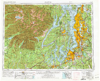
1958 Map of Seattle
USGS Topo · Published 1975About this map
Seattle, Tacoma, and Olympia anchor the dense urban corridor of the Puget Sound region in this 1950s survey, revised in the mid-1970s. The landscape is defined by the complex waterways of Puget Sound and Hood Canal, which separate the industrial centers of the mainland from the Kitsap Peninsula and the massive wilderness of Olympic National Park. The map reveals a post-war landscape of rapid suburban expansion around Lake Washington and the development of major transit arteries like Interstate 5.
Find a feature on this map
228 named features on this map. Tap any name to fly to it.
Don’t see what you’re looking for? This feature index may not catch every label — zoom into the map to look around manually.
Map Details
Editions of this 1958 Seattle Map
3 editions found

Other maps of this area

1894 · Seattle
USGS Topo · 1:62,500

1895 · Snohomish
USGS Topo · 1:125,000

1897 · Tacoma
USGS Topo · 1:125,000

1897 · Seattle
USGS Topo · 1:125,000

1899 · Stillaguamish
USGS Topo · 1:125,000

1900 · Tacoma
USGS Topo · 1:125,000

1901 · Stilaguamish
USGS Topo · 1:125,000

1908 · Seattle
USGS Topo · 1:62,500

1909 · Seattle Special
USGS Topo · 1:62,500

1911 · Mount Vernon
USGS Topo · 1:125,000