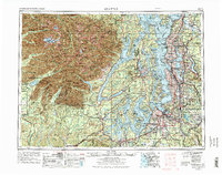
1958 Map of Seattle
USGS Topo · Published 1975About this map
Puget Sound and its complex network of inlets and islands form the heart of this regional study, which captures the Puget Sound Lowlands and Olympic Peninsula during a period of massive suburban expansion. The infrastructure of the Cold War and mid-century industry is evident, from the Puget Sound Naval Shipyard at Bremerton to McChord Air Force Base near Tacoma. The burgeoning highway system, including the newly established Interstate 5 corridor, links major centers like Seattle, Everett, and Olympia, while older rail lines like the Milwaukee Road and Northern Pacific RR still navigate the river valleys. To the west, the rugged wilderness of Olympic National Park stands in sharp contrast to the dense residential growth appearing around Lake Washington and Bellevue. This map provides a clear record of the region's mid-1970s landscape, just as the Eastside was becoming a major metropolitan hub.
Find a feature on this map
190 named features on this map. Tap any name to fly to it.
Don’t see what you’re looking for? This feature index may not catch every label — zoom into the map to look around manually.
Map Details
Editions of this 1958 Seattle Map
3 editions found

Other maps of this area

1894 · Seattle
USGS Topo · 1:62,500

1895 · Snohomish
USGS Topo · 1:125,000

1897 · Tacoma
USGS Topo · 1:125,000

1897 · Seattle
USGS Topo · 1:125,000

1899 · Stillaguamish
USGS Topo · 1:125,000

1900 · Tacoma
USGS Topo · 1:125,000

1901 · Stilaguamish
USGS Topo · 1:125,000

1908 · Seattle
USGS Topo · 1:62,500

1909 · Seattle Special
USGS Topo · 1:62,500

1911 · Mount Vernon
USGS Topo · 1:125,000