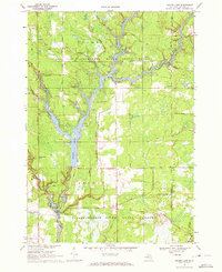
1969 Map of Secord Lake
USGS Topo · Published 1972About this map
Secord Lake and the branching waters of the Tittabawassee River dominate this Central Michigan landscape within the Tittabawassee River State Forest. The map documents a recreational and industrial corridor shaped by the Secord Dam and its associated Powerhouse, which created the expansive reservoir that now defines the local geography. Several small communities and landmarks appear along the timbered banks, including Secord, the nearby Secord Ch, and the settlement of Bowmanville to the east. The presence of numerous sandpits and a Lookout Tower speaks to the region's managed forest resources and local extraction. Significant secondary roads like Meridian Road and Bowman Road provide access to established recreational sites such as Secord Lake Campground and Wildwood Campground, reflecting the area's mid-century development as a destination for outdoor enthusiasts.
Find a feature on this map
50 named features on this map. Tap any name to fly to it.
Don’t see what you’re looking for? This feature index may not catch every label — zoom into the map to look around manually.
Map Details
Editions of this 1969 Secord Lake Map
2 editions found
Other maps of this area

1954 · Traverse City
USGS Topo · 1:250,000

1954 · Midland
USGS Topo · 1:250,000

1958 · Traverse City
USGS Topo · 1:250,000

1958 · Midland
USGS Topo · 1:250,000

1959 · Midland
USGS Topo · 1:250,000

1966 · Midland
USGS Topo · 1:250,000

1968 · Sterling SW
USGS Topo · 1:24,000

1968 · Sterling NW
USGS Topo · 1:24,000

1969 · Edwards
USGS Topo · 1:24,000

1969 · Butman
USGS Topo · 1:24,000