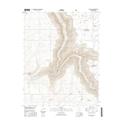
2016 Map of Secret Canyon
USGS Topo · Published 2016About this map
The Dolores River carves a deep path through this portion of Dolores County, defining the central topography of the Dolores Canyon. This 2016 survey illustrates a landscape primarily shaped by water management and public lands, with the eastern half of the map dedicated to the San Juan National Forest. The map details a sophisticated network of upland water storage including Rogers Reservoir, Dalton Reservoir, and the numerous numbered catchments like Big Water Reservoir Number One and Wild Bill Reservoir Number Eight.
Find a feature on this map
50 named features on this map. Tap any name to fly to it.
Don’t see what you’re looking for? This feature index may not catch every label — zoom into the map to look around manually.
Map Details
Editions of this 2016 Secret Canyon Map
This is the sole edition of this map. No revisions or reprints were ever made.
Other maps of this area

1949 · Egnar
USGS Topo · 1:24,000

1949 · Joe Davis Hill
USGS Topo · 1:24,000

1950 · Joe Davis Hill
USGS Topo · 1:24,000

1950 · Egnar
USGS Topo · 1:24,000

1956 · Cortez
USGS Topo · 1:250,000

1957 · Cedar 3 NW
USGS Topo · 1:24,000

1958 · Cortez
USGS Topo · 1:250,000

1959 · Cortez
USGS Topo · 1:250,000

1962 · Cortez
USGS Topo · 1:250,000
1964 · Dawson Draw
USGS Topo · 1:24,000