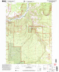
2001 Map of Secret Spring Mountain
USGS Topo · Published 2004About this map
The Klamath River winds through the northern reaches of this landscape, serving as a focal point for historic activity near the settlements of Beswick and Klamath Hot Springs. Situated within the Klamath National Forest, this territory is defined by its deep canyons and numerous water sources. Family-named sites like Spannaus Ranch and Hessig Ranch provide insights into early land use and homesteading patterns in this part of Siskiyou County.
Find a feature on this map
31 named features on this map. Tap any name to fly to it.
Don’t see what you’re looking for? This feature index may not catch every label — zoom into the map to look around manually.
Map Details
Editions of this 2001 Secret Spring Mountain Map
This is the sole edition of this map. No revisions or reprints were ever made.
Other maps of this area

1886 · Shasta
USGS Topo · 1:250,000

1891 · Ashland
USGS Topo · 1:250,000

1893 · Ashland
USGS Topo · 1:250,000

1894 · Shasta
USGS Topo · 1:250,000

1897 · Ashland
USGS Topo · 1:250,000

1934 · Macdoel
USGS Topo · 1:96,000

1941 · Macdoel
USGS Topo · 1:125,000

1948 · Weed
USGS Topo · 1:250,000

1950 · Weed
USGS Topo · 1:250,000

1954 · Macdoel
USGS Topo · 1:62,500