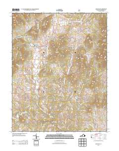
2013 Map of Sedalia
USGS Topo · Published 2013About this map
The Big Otter River and its numerous tributaries, including N Otter Cr and Roaring Run, define the rolling geography of Bedford County in this modern survey. Several established settlements and crossroads dot the landscape, such as Sedalia, Charlemont, and Otterville, reflecting a dispersed rural community structure centered around historic road networks. Notable landmarks like Coltons Mill and Lone Pine indicate localized hubs of activity, while the surrounding terrain is marked by prominent peaks including Flint Stone Mountain, Grassy Mountain, and Hurricane Mountain. Local history and genealogy researchers can trace the specific proximity of family-named roads and drainage basins, such as Lillies Br and Reed Cr, which have shaped the settlement patterns of this Virginia piedmont region for generations. The inclusion of Bedford Lake and numerous small creek crossings suggests a landscape where water resources remain central to the local identity.
Find a feature on this map
101 named features on this map. Tap any name to fly to it.
Don’t see what you’re looking for? This feature index may not catch every label — zoom into the map to look around manually.
Map Details
Editions of this 2013 Sedalia Map
This is the sole edition of this map. No revisions or reprints were ever made.
Other maps of this area

1890 · Roanoke
USGS Topo · 1:125,000

1891 · Roanoke
USGS Topo · 1:125,000

1892 · Lynchburg
USGS Topo · 1:125,000

1894 · Natural Bridge
USGS Topo · 1:125,000

1894 · Lexington
USGS Topo · 1:125,000

1894 · Natural Bridge
USGS Topo · 1:62,500

1907 · Natural Bridge Special
USGS Topo · 1:62,500

1935 · Buena Vista
USGS Topo · 1:48,000

1939 · Buena Vista
USGS Topo · 1:62,500

1940 · Buena Vista
USGS Topo · 1:62,500